1. Introduction to Urbanization in Port of Spain
Urbanization refers to the
increasing shift of persons from rural to developed areas (BBC 2014). It predominantly results
in the physical growth of areas, be it horizontal or vertical (Hogan
2014). Urbanization may be influenced by, economy, demography, technology, politics, society culture and the environment. Culture can be defined as, " The beliefs, customs, arts of a particular society." (Webster 2014). History refers to the study of past events (Webster 2014). This blog aims at discussing the effects of urbanization on the historical and cultural aspects of the Central Business District (CBD), Port- Of – Spain.
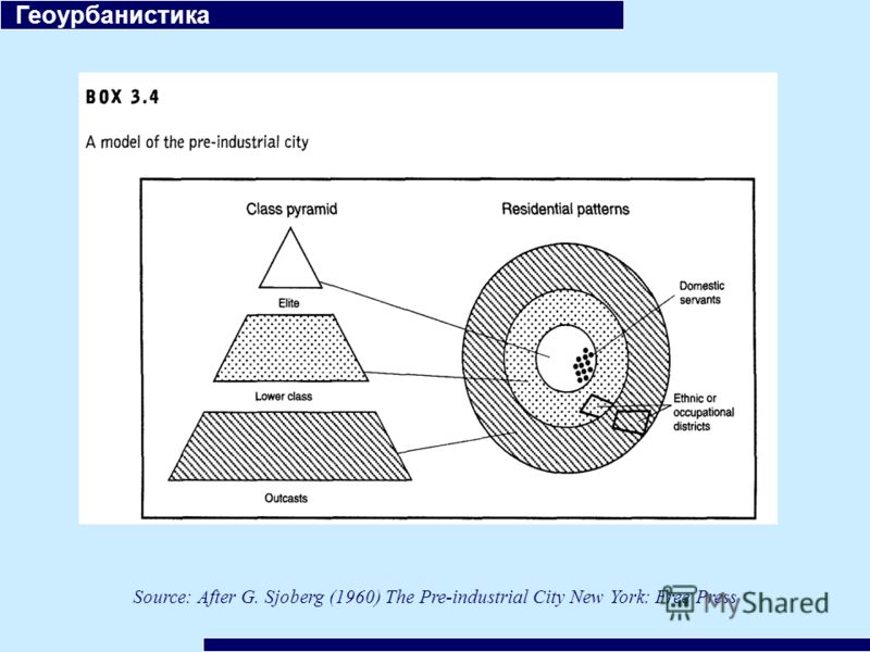
The history of cities began with Sjoberg's Model. During the pre industrial era all cities were classified as the same. The center of the city was always the Central Business District (CBD). The head of the governments were located there and it was the residence of the elite in society as seen in the diagram below. Over time, there is similarities in that the main government buildings, high class venues and major buildings of commerce are still located in the center of the CBD. However, the major difference is that the elites no longer live in this area.
Port- Of-Spain is the
capital of the Trinidad and Tobago. It has an estimated population of 49,657 (google map data 2015) ,contributing to its rapid
rate of urban growth. Common to many urban centers
and evident in the photos blogged, sites of historical and cultural value
can be displayed all over this rapidly expanding city. This increasing space has also had an impact on the city both culturally and historically.
The history of cities began with Sjoberg's Model. During the pre industrial era all cities were classified as the same. The center of the city was always the Central Business District (CBD). The head of the governments were located there and it was the residence of the elite in society as seen in the diagram below. Over time, there is similarities in that the main government buildings, high class venues and major buildings of commerce are still located in the center of the CBD. However, the major difference is that the elites no longer live in this area.
 |
| Diagram Of Sjoberg's Pre Industrial Model (Sjoberg 1960) |
References:
BBC 2014. Geography Urbanisation in MEDCs. Accessed April 5, 2015.
http://www.bbc.co.uk/schools/gcsebitesize/geography/urban_environments/urbanisation_medcs_rev1.shtml
Sjoberg, Gidden.1960. "The Pre Industrial City." New York Time Press
Google Maps 2015. "Maps Lab." Accessed April 4, 2015
https://maps.google.com/maps/myplaces?ctz=-120&t=h&z=17&dg=feature
"Merriem Webster," 2015. Accessed, April 7, 2015. http://www.merriam-webster.com/dictionary/transport.
